Merelake Way
Alsager
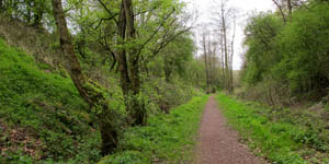
 The Merelake Way is an approximately 1 mile / 1.5 km long trail for walkers, located on the Southern edge of Alsager. There is seating along the length of the surfaced trail and views across adjoining countryside.
Once a railway line the Merelake Way follows a wooded cutting as it climbs uphill towards the Staffordshire border at Merelake.
There are several connecting public footpaths and walkers can devise circular walks using Ordnance Survey maps. The O.S Explorer series sheets required are Crewe and Nantwich 257 for the countryside to the West of the Merelake Way, and sheet number 258, Stoke on Trent and Newcastle under Lyme for the area to the East.
Walkers can enjoy excellent bird watching in the wooded cuttings along the Merelake Way.
Directions:
If using satellite navigation the nearest postcode is ST7 2PP. Grid Reference of car park: SJ 806 551
Discover more countryside sites
See all our countryside sites
Page last reviewed: 04 November 2024
Thank you for your feedback.